
St. Albans ZIP Coverage
The verified city mailing core is 25177. USPS operates the Saint Albans Post Office at 431 B Street, Saint Albans, WV 25177-9998. Other ZIPs appear under a Saint Albans label in a postal processing table, but that grouping is not a municipal boundary list. The distinction is central to a St. Albans ZIP code directory.
| ZIP | Area evidence | Postal point | Boundary note |
|---|---|---|---|
| 25177 | Saint Albans city mailing addresses | Saint Albans Post Office | Primary city ZIP; verify each full address |
| 25107, 25108 | USPS DMM L012 label group | Destination grouping | Not proof of city-limit placement |
| 25112-25113, 25123-25125 | USPS destination grouping | Destination grouping | Check postal and parcel geography |
| 25130, 25133, 25136, 25140, 25142-25143 | USPS destination grouping | Destination grouping | Do not call these city ZIPs without verification |
| 25154, 25156, 25159, 25168, 25181, 25186-25187 | USPS destination grouping | Destination grouping | Routing does not establish incorporation |
No official USPS city-limit ZIP boundary map or St. Albans per-ZIP population table was located. Use 25177 as the confirmed core, not as proof that each address shares one civic layer.
Verify St. Albans ZIP 25177
The USPS ZIP Code Lookup has three modes: By Address, By City and State, and Cities by ZIP. The address form asks for an optional company, required street address, optional unit, required city and state, and an optional ZIP. A standardized result confirms postal format. USPS warns that it does not confirm that a person or firm is at an address.
- Enter the full street and unit in By Address.
- Use Saint Albans and West Virginia for a broad postal check.
- Copy the standardized city, state, ZIP, and unit format.
- Compare it with parcel geometry or a city ward map.
- Confirm a resident name in a lawful official record.
The post office phone is 304-722-2198. Retail hours are Monday through Friday 8:15 to 4:45 and Saturday 9 to 1. Counter staff can answer delivery questions, but they do not certify who lives at a home.
Saint Albans Postal Label Quirk
USPS Domestic Mail Manual table L012 groups many destination ZIPs beneath “SAINT ALBANS WV 25177.” That line can resemble a list of ZIP codes inside the city when read without its shipping context. It is a destination-label and container grouping. It does not redraw St. Albans city limits.
For a borderline address, keep three answers separate: the mailing city from USPS, the parcel location shown by West Virginia GIS, and the incorporated city shown on municipal maps. A directory search can fail when one database uses a mail label and another keys on a tax district or legal description.
Unit detail also matters. USPS asks for an apartment, suite, or other unit when applicable because one base street address may yield more than one postal match. A missing unit can leave the result broad. The standardized address should then be used as a search term, not treated as evidence about any person.
St. Albans ZIP Property Search
The West Virginia IAS property search exposed a ZIP Code field during inspection, with Parcel ID, Parcel State Class, Parcel Address Number, and Street. It was in maintenance mode, so current result behavior was not verified. Treat it as a ZIP-capable property portal, not a list of residents.
| Search control | Type | Required | Purpose |
|---|---|---|---|
| Parcel ID | Text | Not stated | Narrow a known parcel |
| Parcel State Class | Class control | Not stated | Limit by property class |
| Parcel Address Number | Text | Not stated | Add a house number |
| Street | Text | Not stated | Reduce ZIP-wide matches |
| ZIP Code | Text | Not stated | Match the postal value |
The captured state property portal shows the official start screen.
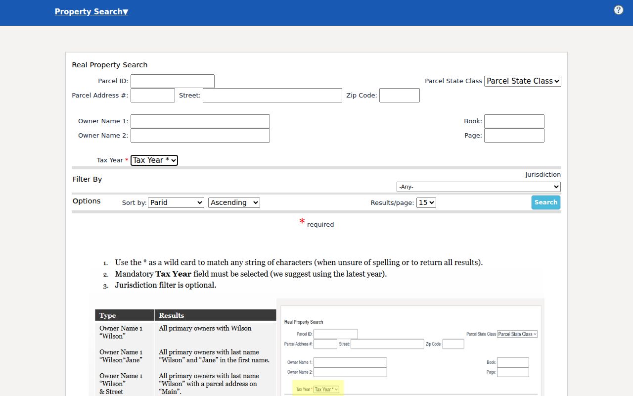
When service resumes, inspect the situs and mailing fields. The mailing ZIP may describe where tax notices go, not where the land sits.
Find St. Albans Residents by ZIP
A ZIP code directory narrows a large set to a postal area. It should not merge a person with a parcel on that fact alone. Start with USPS, use IAS when available, then verify the parcel in WV Property Viewer or the Kanawha Assessor search.
- Standardize the full address with USPS.
- Enter the ZIP in IAS, then add a street or number.
- Check parcel shape, tax district, and physical address in GIS.
- Compare the owner's mailing address with the situs.
- Move to the St. Albans street directory for address-level work.
The voter self-lookup has no ZIP field. It requires first name, last name, and date of birth. It is not a ZIP-wide export. County public-list access follows state law and only permits designated fields.
St. Albans ZIP Address Keys
Several address fields can point toward one parcel, yet they do different work. Keep them distinct when checking a St. Albans ZIP code directory result. The strongest bridge across old and new records is often the parcel or legal description, not the mailing label.
- ZIP code
- A five-digit USPS delivery area, not an incorporated city border.
- ZIP+4
- A more specific delivery segment within a five-digit area.
- Carrier route
- A postal delivery sequence within a ZIP.
- Situs address
- The taxable physical address assigned to a parcel.
- Legal description
- The deed, lot, block, map, or bounds wording that identifies land.
A PO box can serve as a mailing address without identifying the parcel. No separate PO-box-only St. Albans ZIP was verified. Avoid adding one from an unofficial list.
St. Albans ZIP Versus Limits
St. Albans ward and voter precinct maps show civic geography, while USPS labels organize delivery. Census place geography supplies city statistics. None of these layers is identical. The St. Albans documents page publishes City Council Ward and Voter Precinct maps, with water and stormwater material.
Use parcel geometry for land, the city map for municipal placement, and USPS for the mail label. Ask the City Clerk for a boundary or annexation record if those maps do not settle the question. The County Clerk and Archives can help with older maps. KCPL directories may show the address form used in a given year.
West Virginia GIS accepts a city and state address in its E-911 search, but the inspected tool did not show a ZIP-only field. Owner, parcel, and map geometry searches are its better role. The Kanawha Assessor classic form showed a parcel address field, not a confirmed ZIP filter. Search by street there, then read both the situs and mailing address on the parcel card.
Note: Ward, precinct, tax district, postal ZIP, census place, and neighborhood are distinct labels even when their outlines overlap.
St. Albans ZIP Population Context
Census QuickFacts reports 10,861 St. Albans city residents in 2020, against 11,044 in 2010, and a 2025 estimate of 10,210. The city had 3.62 square miles of land and 3,004.4 people per square mile in 2020. These counts describe the incorporated city, not every address carrying a Saint Albans postal label.
Population totals are context, not a resident roll. They cannot identify a household, show a current occupant, or allocate residents among all ZIPs in the DMM group. No official St. Albans per-ZIP population table was found.
For offline access, use the USPS counter or phone for delivery questions, assessor and GIS offices for parcel geography, the City Clerk for maps and public boundary files, the County Clerk or Archives for historic maps, and KCPL for old directories. A focused West Virginia Freedom of Information Act request can reach a custodian when a known boundary record is not posted.